Sonya and I agreed that we would not blog our trip south this year, as we are staying in Palm Springs for the most part.
However, she did sign us both up for a Photography Workshop in - you guessed it - Death Valley! This amazing area, and the fact that we were out there to learn and practice photography, made me think that we should do a Death Valley Special blog post, so here it is.

Death Valley is a desert valley located in Eastern California. The Badwater Basin (pictures to follow) within the valley is the lowest elevation point in North America at 282 feet (approx 86 meters) below sea level.
Furnace Creek (-190 feet below sea level where we stayed) holds the record for the highest reliably recorded air temperature in the world, 134 °F (56.7 °C) on July 10, 1913.

The valley received its English name in 1849 during the California Gold Rush. It was named by prospectors and others who sought to cross the valley on their way to the gold fields, believing it to be a shortcut. After barely surviving the trek, they called it Death Valley.
A number of mining companies came into the valley to mine the gold, silver and borax within the valley. Do you remember the 20 Mule Team Borax?

Death Valley is the origin point of that Borax! The Borax mines did not prosper that long, and by 1910, most mining operations had ceased.
Death Valley National Park is the largest park outside of Alaska, covering 3.4 Million acres. And why not declare it a park, not much can grow here, although the Timbisha Shoshone tribe of First Nations people have lived there for more than a millennium. The Park was established as a National Monument in 1933 and was expanded and became a National Park in 1994.
We arrived in time for our Thursday afternoon outing to catch a sunset and to capture some of the different textures of the land.

Our guides and instructors are two fine gentlemen that co-own a company called From Sea to Summit Workshops (Joshua Cripps and Jim Patterson). You can learn more about them here:
http://www.seatosummitworkshops.com/about-sea-summit-workshops/
In our introductory lecture, they said that landscape photography is looking for patterns that appeal to the eye and capturing them in a way that draws the viewer into the picture.
Here I am trying to find a pattern on the valley floor.

You figure out if there is a pattern!
As you can see below, Sonya almost caught my best side (?) while I wasn't looking!

As this class was about landscape, we should at least have a few landscape shots. Here is one from the first afternoon without me spoiling the view!

As the sun goes down, the colours naturally soften. Here, Sonya catches one of the many paint by number style photos that can be had in the valley.
When you are lucky enough to have clouds in the sky, you often get the soft pink hues associated with pretty sunsets. Here is our first sunset in Death Valley.

As you can see, there is quite a bit of vegetation despite the lack of rainfall in the area. An aquifer runs below the valley, which also explains how there is a town at Furnace Creek!
The next morning we were up before 5 am for an 0530 departure to Badwater Basin, the lowest point in North America. Both Sonya and I were reminded very much of being on the Uyuni Salt Flats in Bolivia. This basin is much smaller, but still impressive.

This B&W shot will make you think that you are on a frozen lake, particularly when you see how most of us are dressed!
Sonya caught a pretty interesting sunrise on her new camera. Our instructors said that if you catch the sun correctly, as it comes up over the mountain, you will get a starburst pattern. Sonya got passing grades on this one!
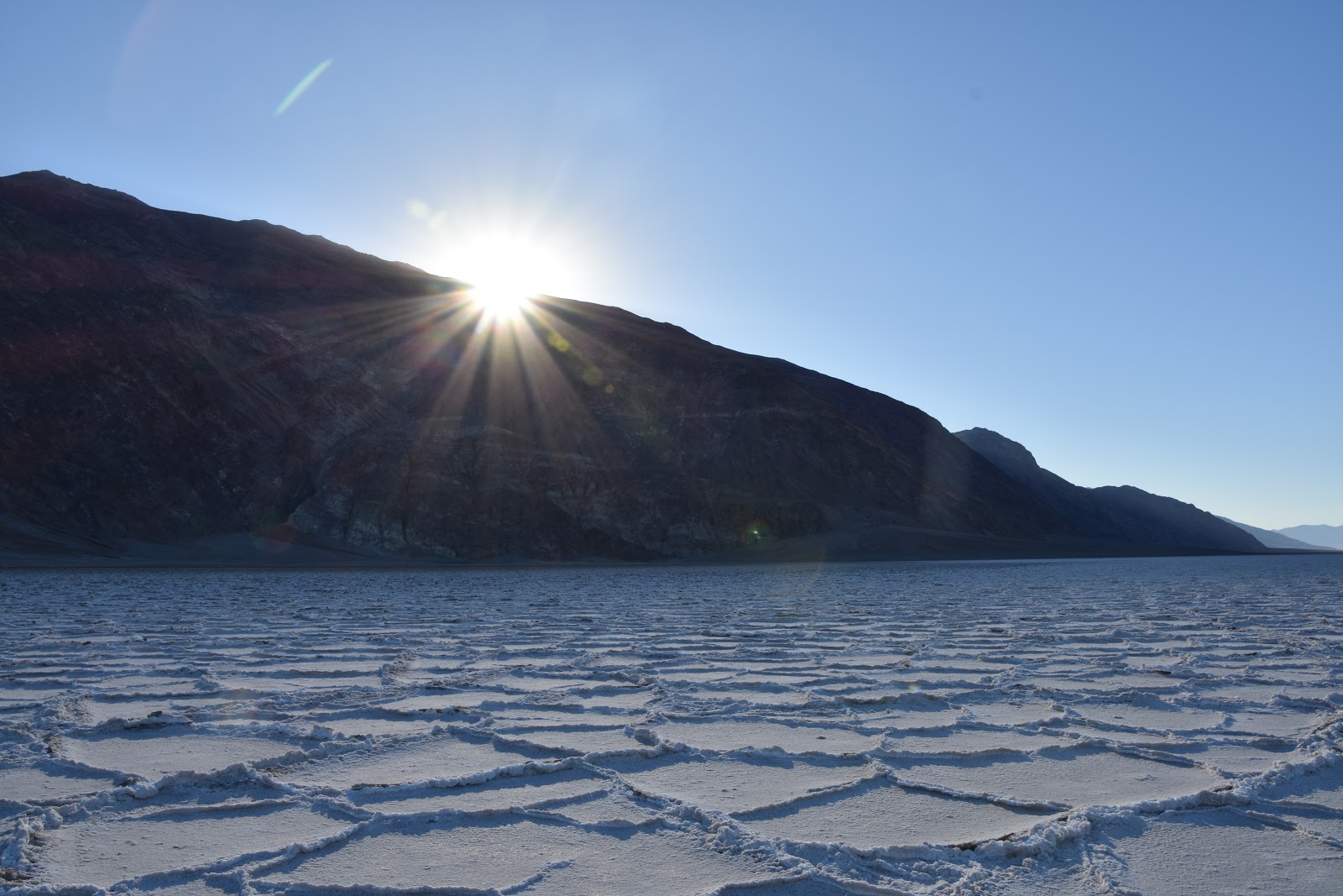
Not to be outdone, I too took one of these and got (I thought) some pretty breathtaking results - see for yourself!

I was feeling pretty smug about that one, until I showed it to one of our instructors (Jim), who simply said, "Oh, you have dust on your lens that you should probably clean off to get a better shot!" What the heck!!!
Sonya's shot here with some of the other attendees gives a bit of perspective of the width of the basin (about 5 miles). It is about 7.5 miles in length.

As we were leaving Badwater Basin, one of the instructors had spotted an old road sign that had made it onto the field somehow.

Not wanting to leave it on the site after having found it, I volunteered to take it back and dispose of it. As you cans see, the walk to and from the basin was not a typical walk in the park!
After we were done with Badwater Basin, we were off to Golden Canyon. You can probably tell where it got its name just by looking.
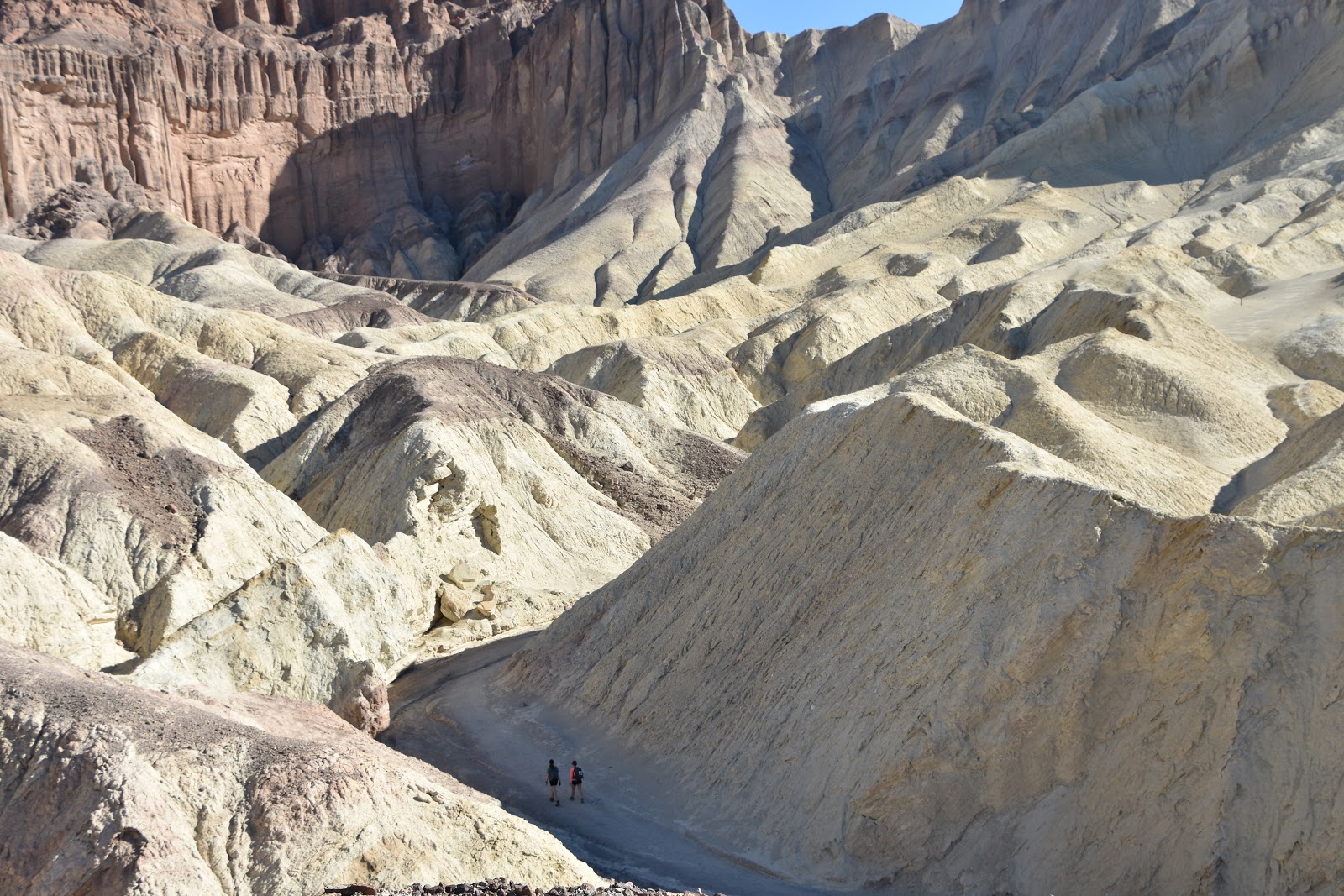
Yes, those are two people hiking the trail down there.
We had a great vantage point to overlook the trail.

Here Jim is providing some basics on white balance in your pictures, something all DSLR cameras have nowadays. Choosing the right one is important, as it has a dramatic effect on the picture. Fortunately, for most people, the cameras default to automatic white balance mode, so you can get a respectable shot even if you know nothing about it!
That trail that you saw, two pictures up, leads to this area.

If you look just to the right of the peak and down to its base (be sure to squint to see it!), you can see the walking path. While I love to walk, I was glad that it was those two in the first picture doing the hike and not us!
Lest you think that it is a short easy hike, here is one more picture to put things in perspective!

Later that afternoon when the sun was well into its descent, we went for another round of shooting. Off to Cottonball Basin!
This may give you an idea of why it is called that.

Here we are lining up for the sunset shot that all photographers want to capture.

Sonya got a pretty good one of her own (even if the one above was impressive from a colour perspective).

A quick side note here. Neither Sonya nor I will ever look at a photo again with the same perspective. While we were at this seminar, we learned that with Photoshop and Lightroom from Adobe, you can edit your photos to look stunning! Indeed, we saw the before and after effects of one of our co-students, and it is amazing what you can do with these tools. For the record, all of the photos you see in this blog (as well as our other blogs) have not been retouched or edited except for size to fit the blog!
Anyway, back to the story.
After we were finished with Cottonball Basin, we went for a quick bite to eat so that we could go back out in the dark to try some night photography. This is something that has always fascinated me. Since the camera I was using had no hope of capturing any night shots, Sonya let me use her DSLR to play around.
We went to a place called Natural Bridge to capture it at night and to play with light. The guys showed us how to use a really high ISO (don't worry about what that is) to capture a quick shot to focus in on what you wanted to capture. Keeping in mind that it is pitch dark, and you have no idea what you are shooting, here is my first effort.

Yes, that is a large hole in the wall, or a natural bridge as the Park prefers. As you can see, it almost looks like a cloudy day in this picture, but it is pitch black outside, except for a near full moon. You can see some of the light from others' flashlights in the foreground to the right.
After we got zoned in, one of the two instructors painted the walls behind us with a bit of light, while the other used a smaller light to paint the opening a bit. Here is the result.

It gives kind of an ethereal effect to the passage. Note how the sky almost looks like daylight, even though it is 9 pm (with a 4 pm sunset)! Although they are almost impossible to see, there are about 1/2 dozen stars in that sky.
Early again the next morning, we were off to an area simply called Salt Springs. Sonya was (as ever) prepared for the program, as she had thought to pack our duck boots (as I call them) so as to not get our running shoes mucky with mud and salt!
This will give you a sense of why they call it Salt Springs.

OK, I think I see a pattern that I can perhaps capture.

Still, the sun is not quite giving enough light, so I have to wait for just the right shot! Sonya used the effect of the sunrise really well here, as she captures the mountains reflecting in the salt springs.

Here is yet another one of her lovely sunrise shots.

Jim was great in one-on-one lessons with both of us. This time it was Sonya's turn.

Recall from above that I said the park was some 3.3 Million acres. Here a few thousand of them for you.

If you look closely to the right of where I am standing, you will see our cars parked a little more than 1/3 of a mile away (for perspective).
We had some time before we went for our next shoot, so I wanted to go see the Devils Golf Course. I wanted to see if I could get a wee bit of golf in.

As we turned the corner, I figured out that a round of golf was out of the question! Here is the first tee. You have to be pretty desperate for golf to want to play this course!!

I stopped mid swing as I realized that if I was not right on, it would cost me a new driver.

Hmm, maybe I should have followed through that swing so I could justify getting the latest club!
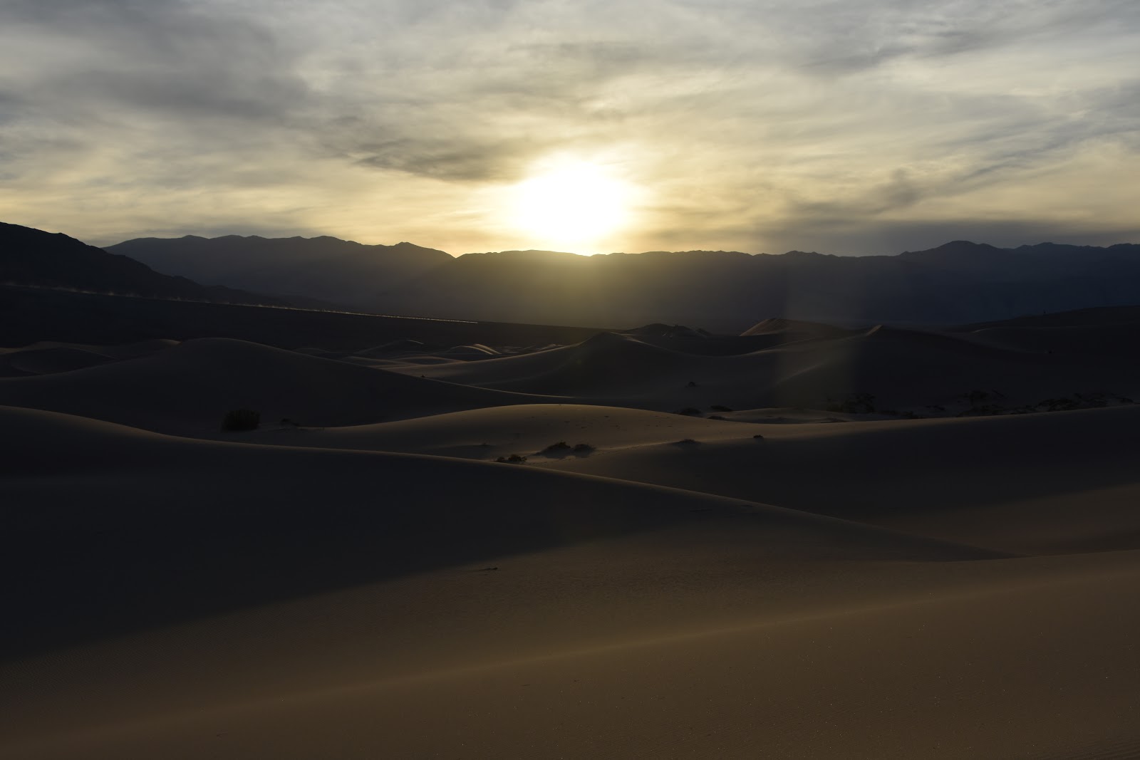
On Saturday afternoon, we were off to the Mesquite Flat Sand Dunes. If you have ever tried to climb a pile of sand, you will appreciate that you take two steps up and slide about 1.5 steps back, so it takes some time to climb. The dunes are really large sand piles, and they cover about 14 square miles in this particular area. They are not the biggest dunes in the area, but they are the most accessible. They do not rise that high (140-170'), but it was enough of a challenge getting up these dunes, given that it takes eight steps to get up two!

It takes a wind of as little as 10 mph to start moving and shifting these sands. The dunes are constantly evolving, so what you may have seen last year, is likely gone and moved to a new dune now!
Even here though, you can find life amongst the sand.

Almost every married person believes that they would walk to the ends of the earth for their spouse. There were times during this walk, that it almost felt that way.

The best way to navigate the dunes is to walk on the top. Here you can see some of the footprints of those that went before us.

Here we captured one last sunset before we went for dinner, prior to another night shoot!
After dinner, we came back to the dunes to capture a night shot of a tree that was near the parking lot.

As you can see, we were playing with light once again.

One final shot before heading back to Furnace Creek.
On Sunday morning, we went to Zabriskie Point, one of the most photographed areas of the park. Here are a few early morning shots of the paint by numbers scenery.


All in all, we loved our trip to Death Valley. The photography lessons were amazing, the vistas and the surrounding scenery are almost surreal, and you can feel the energy that comes off the land. Neither Sonya nor I are big on returning to places we have been, but we both agreed that we need to come back to Death Valley to see more and to drink in the environment.
Until next time, safe travels and be well,
Paul & Sonya